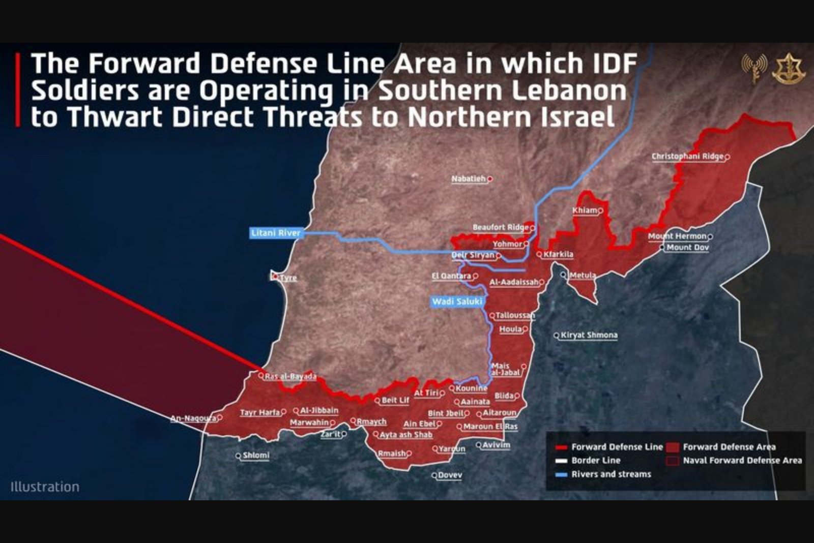
The Israeli military on April 19 published, for the first time, a map showing its newly declared deployment line inside southern Lebanon, a move that places dozens of mostly abandoned Lebanese villages under Israeli control. The release came days after Israel and Lebanon agreed to a U.S.-backed ceasefire following direct talks earlier in the month.
The map indicates a deployment band stretching 5-10 km from the international border into Lebanese territory. Israeli authorities have described the area as a prospective buffer zone and said forces positioned there are intended to prevent threats to northern Israeli communities.
In a statement issued with the map, the military said that "five divisions, alongside Israeli Navy forces, are operating simultaneously south of the forward defence line in southern Lebanon in order to dismantle Hezbollah terror infrastructure sites and to prevent direct threats to communities in northern Israel." The statement did not offer details on timelines for withdrawal or the conditions under which Lebanese civilians might be permitted to return to homes within the zone.
When asked whether residents who fled Israeli strikes would be allowed to return, the Israeli military declined to comment. A separate Lebanese security source reported that some civilians have been able to reach villages on or beyond the Israeli-set line, but that access to most locations south of the line remains restricted by Israeli forces.
Israeli Defence Minister Israel Katz said on Sunday that homes on the border that have been exploited by Hezbollah would be demolished and that "any structure threatening our soldiers and any road suspected of (being planted with) explosives must be immediately destroyed." The minister's remarks reiterate public positions linking demolition measures to force protection and the removal of perceived threats.
The release of the map follows weeks of combat that drew Lebanon into the broader confrontation after Hezbollah opened fire on March 2, saying it was acting in support of Tehran. Lebanese authorities report the Israeli offensive has killed more than 2,100 people, including 177 children, and has driven over 1.2 million people from their homes.
Hezbollah has not released full casualty figures. Sources close to the group said at least 400 of its fighters had been killed by the end of March. The group has carried out hundreds of rocket and drone strikes into Israel, which officials say have killed two civilians. Israel reports that 15 of its soldiers have been killed in Lebanon since March 2.
Israeli forces have previously created buffer zones in other theatres of operations, and the map release confirms that Israel is maintaining positions deep inside southern Lebanon even as a ceasefire is in place. The military statement framed the deployments as actions to dismantle what it terms Hezbollah infrastructure and to reduce direct threats to communities across the border.
The map publication and accompanying statements leave key questions unresolved: the status of dwellings and infrastructure inside the line, the conditions for civilian movement and return, and the duration of Israeli deployments. Lebanese officials and Hezbollah had not commented publicly on the map at the time of the release.
Summary
The Israeli military published a map showing a 5-10 km deployment inside southern Lebanon that brings dozens of mostly abandoned villages under Israeli control. The move follows a U.S.-backed ceasefire and direct talks between Israel and Lebanon earlier this month. Authorities have not clarified whether displaced civilians will be allowed to return, and Lebanese officials and Hezbollah did not immediately respond to the map's release.