A Chinese long-endurance military drone has been repeatedly observed transmitting false aircraft registrations during flights across the South China Sea, according to an analysis of public flight-tracking records and open-source reporting. Between August and mid-February, at least 23 flights used the call sign YILO4200 while broadcasting registration numbers and 24-bit addresses that made the platform appear to be a variety of unrelated aircraft, including a Belarusian Ilyushin-62 cargo jet and a Royal Air Force Typhoon fighter.
Security analysts, military attaches and open-source intelligence researchers who have examined the flight data described the pattern as an escalation in so-called grey-zone operations - activity that falls below the threshold of open conflict but can influence the operational environment and the decision-making of rival militaries. The missions were flown out of China’s Hainan province and consistently moved eastward toward the Philippines, over areas near the disputed Paracel Islands, and along the coast of Vietnam, with some sorties extending toward the Bashi Channel between Taiwan and the Philippines.
Those flight corridors and the shapes of the tracks - often resembling stars or hourglasses - match profiles associated with long-duration surveillance sorties, the analysts said. The aircraft often loitered for hours over particular maritime zones that are known to be of strategic interest, including waters used by submarines, and the flight paths overlaid on maps intersect multiple military points of interest around Taiwan, concentrated near Taipei as well as along the southern coast.
Technical mechanics and transponder recoding
Aircraft broadcast a numeric registration tied to a so-called 24-bit address, governed by the International Civil Aviation Authority, through their onboard transponders. These addresses are unique and publicly catalogued; they help reveal an aircraft’s position, heading and speed to civilian tracking services. Two professional pilots and two independent analysts familiar with the technology told investigators that recoding a transponder to emit an alternate registration is technically possible, which aligns with the pattern seen in the YILO4200 flights.
On multiple occasions, the drone adopted identities that matched specific, real-world aircraft. The most frequent false identity was an Ilyushin-62 operated by Rada Airlines of Belarus. That carrier has been under sanctions by the U.S. Office of Foreign Assets Control since August 2024 for its role in flying personnel linked to Russian-aligned private military groups and for trafficking activities, and its Il-62 has remained active during the period in question under a different call sign.
In one episode spanning August 5 and 6, the drone switched among codes corresponding to four different aircraft over roughly 20 minutes - briefly appearing as a Royal Air Force Typhoon before ending transmissions as the Rada Il-62. In another incident on November 18, the drone appeared as the Belarusian Il-62 while the genuine Rada aircraft was airborne elsewhere, having taken off near Belarus on a flight toward Tehran. The concurrence of these tracks underscores the deliberate nature of the identity switching, analysts said.
Aircraft identification and platform characteristics
Open-source analysts mapped the YILO4200 identifier to a Wing Loong 2 family unmanned aerial vehicle, a Chinese medium-altitude, long-endurance UAV comparable in size to some Western remotely piloted aircraft with a wingspan reported at 20.5 metres. The platform is primarily used for surveillance but can be configured for additional roles, including command-and-control missions, precision strikes and anti-submarine tasks, according to the open-source technical descriptions examined by analysts.
The Wing Loong is produced by Chengdu Aircraft Corporation, a state-affiliated manufacturer that is part of the larger AVIC industrial group. Company representatives declined to comment on the flights when contacted through publicly available channels.
Operational context and potential aims
Observers described the pattern of broadcasts and the choice of false identities as more than incidental or accidental miscodings. "We’ve not seen anything like this before," said one open-source platform founder who analysed the data. "It’s ... a kind of deception trial being carried out in real time using aircraft that are not exactly low profile. It does not appear to be at all accidental."
Analysts cautioned that the masking technique is unlikely to trick trained air traffic controllers or sophisticated military-grade radar systems entirely. Nevertheless, it could introduce costly delays, create operational confusion, conceal sensitive surveillance activities, or be useful as part of information operations - for example in shaping narratives or sowing doubt among observers during a crisis. A fellow at the Pacific Forum in Hawaii framed the operations as one among a suite of digital tactics Beijing might use to "muddy the waters" in the event of escalating regional tensions.
That security analyst said the flights resemble rehearsals for a confrontation rather than simple training flights, noting that anything which injects hesitation or hesitation into automated decision chains - where milliseconds count - would be advantageous to an actor seeking to complicate a rival’s operational picture.
Geography and links to Taiwan
Flight trajectories projected eastwards from Hainan cut through areas of high naval activity, including waters south of the island that sit near Chinese submarine facilities, and track toward the Bashi Channel - a maritime choke point that would be an axis of movement for China’s navy in operations accessing the Pacific. When transposed onto an annotated map of Taiwan, the recorded sorties pass near several military installations and urban centers on the island.
Those eastern routes also bring the drone into proximity with Japanese and U.S. bases in Okinawa and other islands of the Ryukyu chain, adding to the broader regional footprint of the missions. One security analyst described the combined pattern of missions across the South China Sea and toward Taiwan’s approaches as a compelling visual of rehearsals that could be adapted to operations targeting Taiwan’s critical points.
Operational details, airport activity and imagery
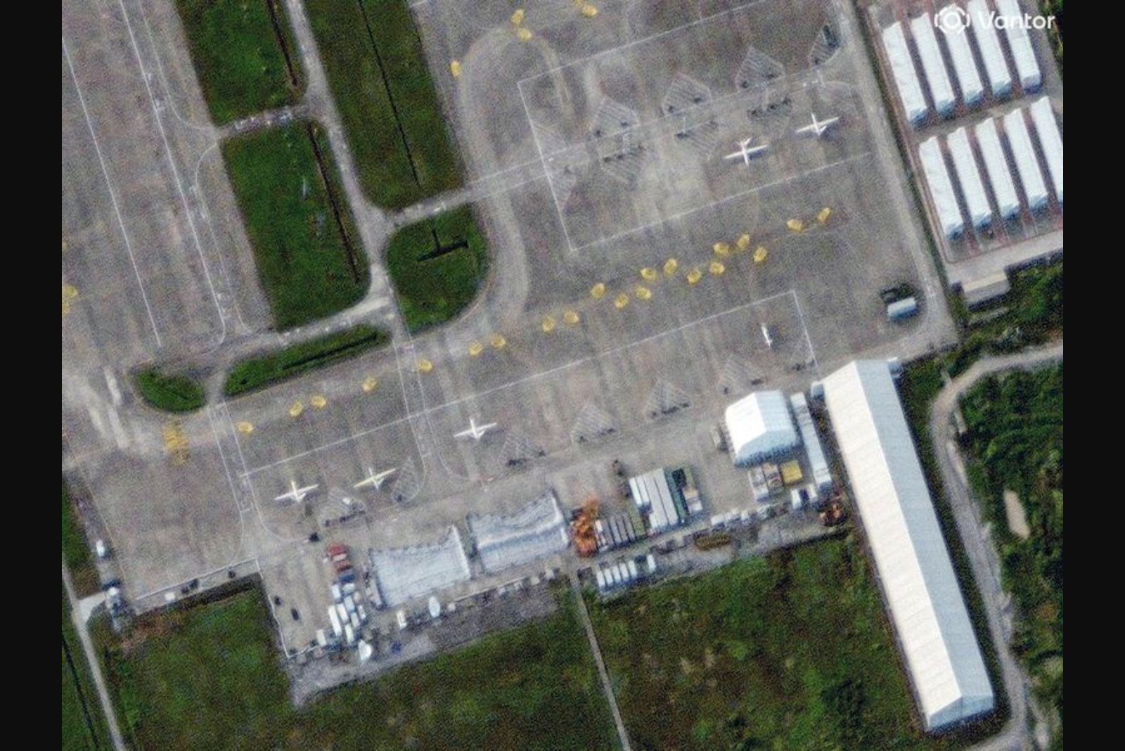
The drone flights generally originated from Qionghai Boao International Airport in Hainan, a facility that serves both civil and military aircraft. Analysts observed that the sorties frequently remained airborne for extended periods and executed repeated loitering patterns over the same maritime areas. Satellite imagery from July, September and January obtained by investigators showed large unmanned aircraft positioned on tarmacs in a portion of the airport where new support buildings are located and which appears to be undergoing expansion.
Some YILO4200 missions also operated in northwest China from mid-December; most recently, on February 15, the platform broadcast itself as an anonymous Pilatus PC-12, a small turboprop passenger aircraft, while airborne over the domestic interior. That diversity of false identities - ranging from executive jets to military fighters to large cargo transports - has been highlighted by analysts cataloguing the radioed registrations against known aircraft.
Institutional responses and open questions
China’s defence ministry did not offer an explanation for the flights when asked through available public channels. The manufacturer of the Wing Loong family did not provide comment. The International Civil Aviation Authority declined to comment on matters concerning specific member states.
Flight-tracking services noted the unusual nature of the broadcasts. A communications director at one tracker said the pattern did not align with ordinary programming mistakes or corrupted data streams; the specific use of legitimate 24-bit addresses and the flight patterns indicate an intentional and coordinated approach. It remains unclear whether the drone missions were flown on automated, pre-programmed paths or were being piloted in real time from ground control.
Analysts also said it was not possible, from the available data, to determine which Chinese agency or service was operating the aircraft from the dual-use airport at Boao. Two other intelligence professionals and an online tracker who examined the records connected the YILO4200 identifier to the Wing Loong platform by cross-referencing flight histories, state press reporting and government notices, and through pattern analysis of the aviation data.
Implications for regional security and operational practice
Observers stressed that the utility of such transponder masking is operationally situational. While unlikely to render sophisticated defensive systems ineffective, it can complicate routine monitoring and create opportunities to hide surveillance over sensitive maritime assets or to distract attention from other activities. In scenarios of high tension, that confusion could have cascading effects on decision-making timelines.
For regional militaries and allied forces that rely increasingly on automated detection and identification chains, the ability of an adversary to inject deceptive signatures into the common operating picture raises questions about verification procedures, rules of engagement and the robustness of air-domain awareness. Analysts emphasised the new element these missions add to China’s growing presence in the South China Sea and around Taiwan - part of a broader push to sharpen force readiness in line with national directives.
Summary of known facts and unresolved points
- At least 23 flights used the YILO4200 call sign since August, with the UAV broadcasting different aircraft identities via transponder data.
- Recorded false identities included an Ilyushin-62 operated by Rada Airlines of Belarus, a Royal Air Force Typhoon, a North Korean Il-62 passenger jet, and a Gulfstream executive jet; one mission later appeared as an anonymous Pilatus PC-12.
- The actual Rada Il-62 remained in operation during the period and at times was airborne simultaneously with the UAV transmissions that mimicked it.
- Flight patterns concentrated over strategic maritime zones south and east of Hainan, near the Paracel Islands, along Vietnam’s coast, and toward the waters east of Taiwan, consistent with surveillance-type loiter profiles.
- Open-source analysts linked the call sign to a Wing Loong 2 family UAV, produced by Chengdu Aircraft Corporation, part of the AVIC group.
As the available evidence stands, the activity represents an observable evolution in the technical and operational toolbox used by the aircraft operator. But several significant questions remain open: who is operating the platform from the Boao airport complex, whether the transmissions are centrally programmed or controlled in real time, and how widespread the use of this transponder-masking technique may be beyond the flights that have been catalogued.