Satellite imagery reviewed by independent analysts reveals a pattern of construction, concealment and repair at multiple Iranian military and nuclear sites. Experts say the changes include the erection of a concrete cover over a recently built facility at the Parchin military complex, burying of tunnel entrances at an Isfahan nuclear installation, defensive hardening of tunnel portals near Natanz and reconstruction work at missile bases damaged during last year’s conflict.
Parchin military complex
Parchin, located roughly 30 km southeast of Tehran, is one of Iran’s most sensitive military locations. Western intelligence agencies have previously suggested that tests relevant to nuclear bomb detonations took place there more than two decades ago; Iran has consistently denied pursuing nuclear weapons.
Analysts say satellite images captured before and after an October 2024 strike, which Israeli sources reportedly carried out, show significant damage to a rectangular building at Parchin followed by reconstruction activity. Imagery dated November 6, 2024 displayed repairs. Subsequent images from October 12, 2025 showed further development with the skeletal frame of a new building and two smaller adjacent structures becoming visible. By November 14 of that year, observers noted what appeared to be a metallic roof covering the larger structure.
Imagery from December 13 then suggested the facility was partly obscured. By February 16, analysts report that the structure could no longer be seen in open images, appearing instead to be hidden beneath what experts identified as a concrete cover.
The Institute for Science and International Security (ISIS), in its January 22 analysis of satellite imagery, described progress in building a "concrete sarcophagus" around the newly constructed facility at the site identified as Taleghan 2. In a November briefing, ISIS had reported imagery showing "ongoing construction and the presence of what appears to resemble a long, cylindrical chamber, maybe a high-explosives containment vessel, likely measuring approximately 36 meters long and 12 meters in diameter placed inside a building".
ISIS added that "High-explosive containment vessels are critical to the development of nuclear weapons," while also noting such vessels can have applications in conventional weapons development processes.
William Goodhind, a forensic imagery analyst with Contested Ground, commented on the recent imagery, saying the new roof displayed a hue similar to its surroundings and "has most likely been covered with dirt to obscure the concrete colour." ISIS founder David Albright wrote on the social platform X that "stalling the negotiations has its benefits: Over the last two to three weeks, Iran has been busy burying the new Taleghan 2 facility ... More soil is available and the facility may soon become a fully unrecognizable bunker, providing significant protection from aerial strikes."
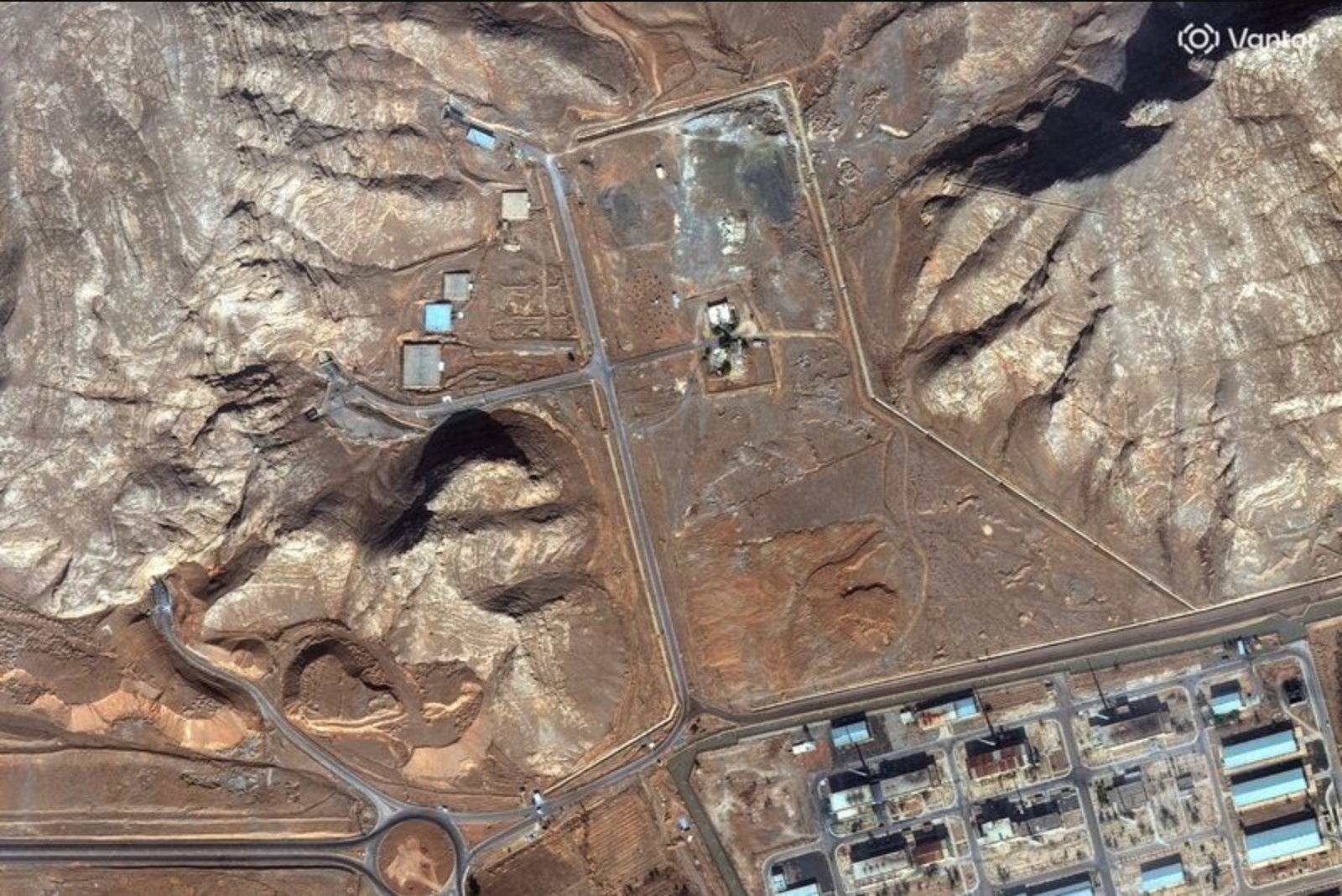
Tunnel entrances backfilled at Isfahan nuclear complex
The Isfahan complex, one of three uranium-enrichment plants reportedly struck by the United States in June, also includes an underground area where diplomats say much of Iran’s enriched uranium has been stored. Satellite pictures from late January showed new activity to bury two tunnel entrances at the complex, according to an ISIS report published on January 29.
ISIS updated its assessment on February 9, saying a third entrance had been backfilled with soil, rendering all entrances to the tunnel complex "completely buried." A February 10 image was cited by forensic analysts as confirming that all three tunnels were buried.
ISIS stated on February 9 that "backfilling the tunnel entrances would help dampen any potential airstrike and also make ground access in a special forces raid to seize or destroy any highly enriched uranium that may be housed inside difficult."
Fortification near Natanz - Pickaxe Mountain
Satellite-based analysis indicates ongoing measures since February 10 to "harden and defensively strengthen" two entrances to a tunnel complex under a mountain approximately 2 km from Natanz, the location of Iran’s other two uranium enrichment plants. Imagery reportedly shows continued activity across the complex, with movement of numerous vehicles including dump trucks, cement mixers and other heavy machinery.
ISIS described the site as Pickaxe Mountain but noted that Iran’s plans for the facility remain unclear.
Missile base repairs: Shiraz South and Qom
Additional imagery-focused assessments cover repair and reconstruction efforts at missile facilities struck during last year’s conflict. The Shiraz South base, roughly 10 km south of Shiraz in southern Iran and identified by the Israeli Alma Research and Education Center as one of 25 primary bases capable of launching medium-range ballistic missiles, showed signs of above-ground damage described as light by Alma.
Comparisons of images dated July 3, 2025 and January 30 indicate reconstruction and clearance activity at the main logistics and likely command compound at Shiraz South. William Goodhind commented that the "key takeaway is that the compound has yet to return to its full operational capacity from prior to the airstrikes."
Some 40 km north of Qom, the Qom missile base sustained moderate above-ground damage, according to Alma. Imagery comparisons between July 16, 2025 and February 1 show a new roof installed over a damaged building. Goodhind said the roof repairs appeared to have begun on November 17 and were likely complete about 10 days later.
Context and implications
The satellite evidence provides a window into a range of Iranian activities at locations that have been focal points for tensions with Israel and the United States. Those tensions include U.S. efforts to negotiate an agreement with Tehran over its nuclear programme, alongside public warnings from Washington that it could resort to military action if diplomatic talks fail. Analysts and imagery specialists emphasize that measures such as backfilling tunnel entrances and burying newly constructed facilities can complicate the effectiveness of airstrikes and ground operations.
While the precise intentions behind some of the construction and fortification work are not publicly known, the imagery and expert commentary together illustrate an active program of concealment, repair and defensive strengthening across several sensitive sites.